LandownerIntel publishes this page and sells reports. This is not an independent ranking. We reviewed public vendor pages, not their paid products. See Sources for the links and review dates.
The four tools you'll likely find
A letter of intent arrives from an LLC you have never heard of. Or it was a phone call, a knock at the door, or a letter with an option agreement attached. Someone wants your land for a data center. The number they offer sounds significant.
Before you respond, you need to know what to check. Nearby power lines, water conditions and climate records can help you frame questions. They cannot tell you whether the parcel is viable for the project or whether the offer is fair.
LandownerIntel, Land id, Acres and Land Owl serve overlapping but different needs. Some help you research, map and share properties over time. LandownerIntel focuses on a one-time location report for a landowner considering a data center proposal.
This comparison is published by LandownerIntel, which sells reports. It is not an independent ranking or legal, engineering or appraisal advice. We reviewed public vendor pages on October 2, 2026. We did not test paid products or audit their accuracy or security. Features, coverage and prices can change.
id.land: parcel research, mapping and reports
Land id serves property owners and buyers as well as agents, investors and other land professionals. Its plans cover parcel and owner information, map layers and tools for presenting a property.
The pricing page lists a basic plan at $7 per month per user, billed annually. Premium lists $12 per month per user, billed annually, with AI parcel insights and mapping. Pro plans add tools such as comparable-sales and soil reports. Check the chosen plan and billing term before purchase.
These tools can help you find ownership records, explore boundaries and map a site. It would be misleading to describe Land id as having no analysis or reporting features.
Our review does not establish a blanket absence of grid, water or climate information across every Land id plan. Ask which layers and sources are available for your location. A map or generated insight is not a utility's promise to serve a large data center load.
Acres.com: mapping, property reports and market research
Acres offers individual plans as well as tools for land teams. Its pricing page lists parcel maps, ownership research, property reports, flood and soil information, sales data and valuation tools. It is not only an enterprise product.
At review, Plus lists $9.99 per month or $7.49 per month with annual billing. Pro lists $124.99 per month or $94.99 per month with annual billing. Pro emphasizes valuation and prospecting; Enterprise adds team features, AI workflows and more layers. Basic free access is also advertised.
A $94.99 headline without the annual-billing condition would give an incomplete picture. Compare the total commitment, the report features and the plan you actually need.
Acres may fit work that involves comparing sales, researching several properties or producing maps and market reports. Our review does not prove that all of its plans lack energy-related layers. Verify the exact sources and coverage. Market data or a valuation estimate also does not certify utility capacity or replace an independent appraisal.
LandOwl: parcel reports and infrastructure layers
Land Owl offers parcel and ownership research, zoning and environmental information, saved maps and reports. Its official website explicitly lists transmission lines, substations, power plants and other infrastructure layers.
It also advertises parcel reports that can be downloaded as PDF or Word files or shared by link. Those features make it inaccurate to call Land Owl only an ownership lookup tool or say it has no grid context.
The pricing page lists a free plan with limits, including one parcel report per month. Basic displays $10 per month with $120 billed annually. The comparison table also displays $20 per month for Basic. Check the selected billing term and final amount rather than treating every displayed price as a month-to-month rate.
Land Owl says saved parcels, tags and notes are private to the account and never shared with other users. Its sharing tools let customers deliberately publish maps or report links. Those tools are not evidence that it sells private customer work to developers or brokers.
These layers can support research, but proximity is still not available capacity. Ask the utility about service for the actual project. Check whether a report includes dated streamflow observations or climate records; do not assume either presence or absence from a list of map layers.
LandownerIntel: a one-time report for the landowner
LandownerIntel focuses on the landowner's side of a data center proposal. Enter an address or coordinates and choose a one-time PDF: Site Basics for $19, Place Context for $29, or Complete Report for $39. There is no report subscription or renewal.
The report brings together a location screening score, nearby tracked development, mapped grid context, and available water and climate records. It shows sources and missing evidence. Place Context adds explanation and climate trends from an operating comparison site. Complete adds a decision checklist and questions about infrastructure duties when an issue is flagged.
All three tiers use the same location evidence. Paying more buys explanation and questions, not stronger verification, a land value or a promise of usable power.
Climate readings at an operating comparison site are context, not a forecast of impacts at your parcel. The report should not be described as simply using the nearest weather station or predicting heat, noise, traffic or water use from a proposed facility.
Water observations are dated readings from available sources. If no active stream gauge is nearby, missing flow and water-level data are marked before checkout and in the report. A gauge reading does not establish a parcel's water rights, future supply or a proposed cooling system's needs.
LandownerIntel takes no sales commissions and does not represent developers. Submitted property details are not shared with developers or brokers as leads. Reports, storage, payments, email and site measurement still use service providers; read the privacy policy.
Two limits matter most: a nearby power line does not prove a project can connect, and a screening score does not prove that an offer is fair. Take project-specific questions to the utility, a local attorney and an independent appraiser.
Side-by-side comparison
This table compares publicly described workflows, not measured accuracy. A listed feature may depend on the plan and location. Where the reviewed pages do not establish a feature, confirm it with the vendor rather than read that uncertainty as a definitive no.
| Question | LandownerIntel | Land id (id.land) | Acres.com | Land Owl |
|---|---|---|---|---|
| Primary workflow | One-time data center location report for a landowner | Parcel research, maps, insights and property presentations | Parcel maps, property reports, market and valuation research | Parcel research, zoning, infrastructure layers, maps and reports |
| Advertised billing at review | $19 / $29 / $39 per PDF; no subscription | Basic $7/mo and Premium $12/mo per user, billed annually; other plans available | Plus $9.99/mo or $7.49/mo annually; Pro $124.99/mo or $94.99/mo annually | Free plan; Basic displays $10/mo with $120 annual billing; confirm selected term |
| Power infrastructure context | Mapped nearby grid features; not available capacity | Check selected layers and coverage; no blanket absence established | Check selected layers and coverage; no blanket absence established | Advertises transmission, substations and power-plant layers; not a service commitment |
| Water and environmental research | Available dated gauge observations; missing readings marked; not water rights | Check selected reports and layers for the needed water observations | Flood, soil and other layers are advertised; confirm the water evidence you need | Flood, wetlands, soils and hazards are advertised; confirm dated water observations |
| Climate context | Available source records and operating-site comparison; not predicted parcel impacts | Verify exact climate sources and plan coverage | Verify exact climate sources and plan coverage | Verify exact climate sources and plan coverage |
| Reports and decision support | PDFs; Complete adds a checklist for adviser and utility conversations | AI insights; Pro lists comparable-sales and soil reports | Property, sales and valuation reports, depending on plan | Parcel reports; PDF/Word downloads and deliberate sharing |
| Need an ongoing subscription? | No; a one-time PDF purchase | Paid plans with a free trial advertised | Free basic access and paid plans | Free plan with limits; paid plans for more access |
| Who must confirm project power? | The utility | The utility | The utility | The utility |
Why the audience mismatch matters
The question is not whether brokers' or investors' tools are useful. They can be useful to landowners too. The question is whether you need an ongoing map workspace, market research, a shareable property presentation or a focused PDF before a conversation.
A person comparing many properties may value saved maps, sales records and repeat research. A landowner responding to one data center offer may prefer a short report with sources and questions to take to advisers.
Do not confuse either workflow with an engineering decision. A substation can be nearby but unable to serve the proposed load. A stream gauge can have readings without giving you a right to take water. A comparison site's climate record cannot predict a new project's local effects.
LandownerIntel is designed for the focused report workflow. The other tools offer wider research and mapping capabilities. Depending on the job, you may use more than one tool—and still need professional review.
What the reports do not do
LandownerIntel reports are screening tools. They do not confirm available utility capacity, a connection date, upgrade costs, water rights or zoning approval. They do not set a fair sale price or lease rate, and are not legal or financial advice.
The Complete checklist is a set of questions for a developer, attorney, utility representative or land-use adviser. It does not replace their project-specific work. The current report is also not a solar feasibility study.
If a developer is serious about your parcel, have local counsel review the option or lease agreement. An independent appraiser can help assess value. The utility must assess service for the proposed load and explain any studies or upgrades it requires.
The report helps you prepare for those conversations. It does not replace them or certify that your parcel is viable for the proposed development.
The right starting point
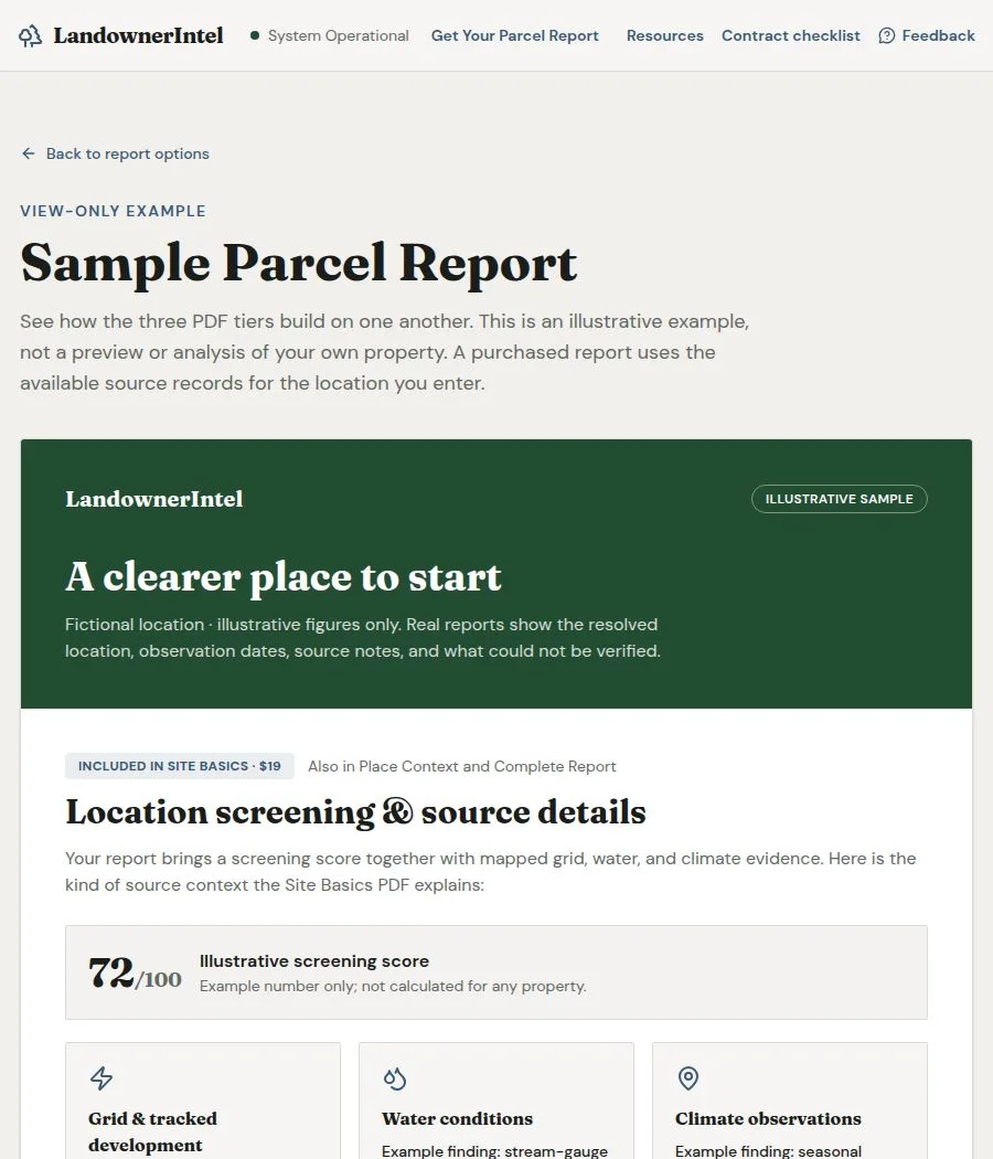
Start with the public sample before buying. It shows the format and how the tiers build on one another. Its location and figures are illustrative—not a live analysis of your property.
If a focused screening PDF fits your need, Site Basics is LandownerIntel's $19 entry tier. It combines the screening score with mapped grid context and water and climate sources. This is an entry price for this product, not a claim that it is the cheapest research option available.
Place Context costs $29 and adds explanation. Complete costs $39 and adds a decision checklist. Choose the detail you need; all tiers use the same evidence.
If you need boundaries, sales comparisons or a map to keep updating and sharing, compare the other vendors' current plans. Before signing anything, take the actual agreement and service requirements to independent advisers.
Conclusion
Choose a tool by the work you need to do, not by a claim that every other product is unsuitable. LandownerIntel offers a focused, one-time screening report. Land id, Acres and Land Owl offer broader mapping, research and reporting workflows.
For a landowner with an unexpected data center offer, the next step is to organize the facts and the unanswered questions. Review the sample, choose a report if it fits, and ask the utility and your advisers to confirm what screening cannot establish.
No subscription is needed for a LandownerIntel PDF. No commission is taken. But one report is a starting point—not a verdict on the project or the deal.
Frequently asked questions
- What is the best tool for a landowner to evaluate a data center land offer?
- It depends on the task. LandownerIntel offers a one-time PDF focused on data center location context and questions for advisers. Land id, Acres and Land Owl offer broader maps, research and reports. None of these workflows replaces a utility service review, legal advice or an independent appraisal.
- Does LandownerIntel confirm that my land has enough grid capacity for a data center?
- No. Mapped proximity to a line or substation does not establish usable capacity, a connection date or upgrade costs. Your utility must assess the proposed load and explain the service terms and any required studies. A screening score is not a power commitment.
- Can I use id.land or Acres.com to evaluate a data center offer?
- Yes, they may help with parcel research, maps, ownership, sales comparisons and reports, depending on the plan. Verify the exact layers, sources and coverage you need. We did not establish that every plan lacks grid, water or climate information. Neither a map nor a valuation tool proves utility capacity.
- Is LandownerIntel a subscription service?
- No. Site Basics costs $19, Place Context $29 and Complete Report $39 as one-time PDF purchases. There is no report subscription or renewal. All tiers use the same location evidence. Higher tiers add explanation and questions, not stronger verification. Check the final amount at checkout.
- What does the Complete tier decision checklist actually do?
- The $39 Complete tier adds questions to prepare for conversations with an attorney, utility representative or developer. It can help identify what to confirm and who should answer. It is not legal or financial advice, does not price your land, and does not replace professional review.
- Does LandownerIntel have any relationship with developers or brokers?
- LandownerIntel takes no sales commissions and does not represent developers. Submitted property details are not shared with developers or brokers as leads. This is not a promise of no third-party processing: reports, hosting, storage, payments, email and site measurement use service providers. Read the privacy policy for details.
- Where can I see a sample report before purchasing?
- The public sample report is available at landownerintel.com/sample-report. It shows how the three tiers build on one another. The location and figures are illustrative. It is not an analysis of your property; purchased reports use the source records available for the location you enter.
Sources and limits
- Land id plans and features
Reviewed October 2, 2026. Lists annual-billed prices, parcel insights, mapping and Pro reporting features.
https://id.land/pricing
- Acres pricing and plan comparison
Reviewed October 2, 2026. Lists monthly and annual prices, property reports, market tools and environmental map layers.
https://www.acres.com/pricing
- Land Owl official product and FAQs
Reviewed October 2, 2026. Explicitly lists energy infrastructure layers, downloadable reports and saved-work privacy.
https://www.landowl.com/
- Land Owl plans and reports
Reviewed October 2, 2026. Lists a limited free plan, annual-billed paid prices and reports. Different billing presentations require checking the selected term.
https://www.landowl.com/pricing
- LandownerIntel report scope
Our product description and limits, not an independent review or proof of parcel viability.
https://landownerintel.com/about
- LandownerIntel pricing
Three one-time PDF tiers share the same evidence; higher tiers add interpretation and questions.
https://landownerintel.com/pricing
- LandownerIntel sample report
Public illustrative example. The embedded screenshot is from this page, not a customer's report.
https://landownerintel.com/sample-report
- LandownerIntel privacy policy
Explains submitted information, service-provider processing, storage, delivery and site measurement.
https://landownerintel.com/privacy
Related pages
See what a report contains
A screening report, not a valuation or a grid-capacity commitment.
Educational information only, not legal, tax, or appraisal advice.